This is the last of the winter. The February days dribble snow, and the basil on the kitchen windowsill huddles in its pot, looking depressed. Archangel, who checks the news and weather on his way out of bed in the morning, says unbelievingly: The weather forecast for today is "Dark." Well, yes.
This is also the last of the Teltowkanal--or strictly speaking, the first of it, since I've been walking upstream. Here the city dribbles out into chaotically half-built areas, reminiscent of those fringes of middling US cities where there are scattered little houses on outsize lots, lugubrious bars with no windows, and gun shops and places to get second-hand parts for your third-hand car.
Gropiusstadt isn't a slum, but it's a bit problematic. Somewhere I read a piece that used the following item as an indicator for Gropiusstadt's not being quite there yet, socioeconomically speaking. (Try using this question to test the okayness of your own neighborhood.) The question is: Does your neighborhood have rush hours on the public transit?
The writer of the piece noted, with something between startlement and horror, that the U-Bahn stations in Gropiusstadt were quite busy for a couple of hours in the morning and a couple of hours in the evening, and then the rest of the time they weren't busy. What an uncomfortable and undesirable thing, thought the writer of the piece. What an un-Berlin kind of thing. (When have I seen the trains busiest on the Stadtbahn, the backbone of the Berlin transit system? The rush hour is not obvious. Summer Sunday evenings when people are coming home from the woods? Saturday nights when the young are headed for the clubs? Weekday midafternoons when the kids get out of school?)
The idea of this criterion is that a real neighborhood is multi-purpose (and life is multi-purpose), and therefore people are coming from the neighborhood and going to it in all directions at all hours of the waking day and night. The neighborhood is not just a place where people are warehoused in their (rigidly designated) off-work hours. (Ah, this was the great mistake of the modernist city-planners in the twentieth century. They were right about Light! Air! Sunshine! [see previous post] But they were wrong about functional separation: the idea that residential and commercial and industrial areas should be quite separate, all sealed off from each other. Terrible idea.)
So Gropiusstadt is a bit too residential-warehouse-like, and some of the industry down here has an un-integrated look as well. History has been rather hard on the area. Having left Gropiusstadt half a mile or so behind, I am in Rudow, which in Cold War days was the last little dangling southeastern bit of West Berlin, surrounded on three sides by the East. The roads stopped here, the rails stopped here, people didn't come here much. Now people pass through, without stopping, along the new freeway that goes down to the nonusable new airport (and on south to Saxony). The place has a semi-coherent, semi-existent sort of feel.
Beyond the bridge where I quit last time, I have a choice of routes. I could cross to the other side of the canal, to a bicycle path that runs narrowly between the water and the freeway fence (and cyclists complain on the web about doddering old pedestrians getting in their way when they're zinging along in eighteenth gear). Or I could stay on this side, on Canalstrasse, where I will see the front of the industry that backs on the canal. Or maybe the back of the industry that fronts on the canal.
Well, Canalstrasse for me: I don't want to breathe auto exhaust for the next hour, and industry is fun, at least sometimes. The industrial strip along the canal, close to the new freeway, looks fairly flourishing. This is good.
The older buildings--refitted and in use--are dignified with red brick and formal design features: the medallion in the gable, the symmetrical window placement, the brick relief panels between the windows. Newer buildings on the street have a form-follows-function character; here, in an expiring breath of classicism, form still follows rules.
The older buildings--refitted and in use--are dignified with red brick and formal design features: the medallion in the gable, the symmetrical window placement, the brick relief panels between the windows. Newer buildings on the street have a form-follows-function character; here, in an expiring breath of classicism, form still follows rules.
 |
| On Canalstrasse, Rudow. February 2015. My photo. |
Much of the street is occupied with little recent-ish business parks with room for six or eight firms, mostly of a metal-bashing or building-related nature. There are also bigger outfits that have whole building complexes to themselves: roofers, tile-layers, firms that do environmental cleanup, a firm that puts coatings on things.
There is a sizable-looking firm called Rip-Wolf that will destroy data for you, in either paper or electronic form. (Okay, I know that Rip-Wolf (Reisswolf) is just the German word for shredder, but the English cognate makes an excellent word, and the firm logo does have a wolf-head on it.)
I am not sure what the people with the bright yellow shed do, other than provide interesting streetscape. (How I love the (unclassical) form of this, the tower with the loader that goes back to the canal, and then the deep-lemon shed that livens up the monochrome of the winter street.)
 |
| On Canalstrasse, February 2015. My photo. |
Canalstrasse is not long, and the trick will be finding a place to get under the highway and back to the water when the street comes to an end. This is straightforward enough if you go down to the next substantial street, but that's somewhat out of the way, and according to one map there is a footpath shortcut that stays closer to the water. According to other maps there is no such thing, but let us travel hopefully.
The shortcut appears to go through a large Mercedes truck dealership. I feel awkward--do I look like a customer for large Mercedes trucks? But I can see the highway up there, and it looks as though there is really an underpass.
Yes. I have made it through the endless lines of vehicles for sale without being challenged by salesmen or run down by customers, and here we go under the highway. We are crossing from the last of the old West to the old East, from Rudow to Altglienicke.
Some of the territory on this side is still a bit unreconstructed-East, broken-windowed in the winter cold.
 |
| On Rudowerstrasse, east of highway, February 2015. My photo. |
Once under the highway, I turn north, back toward the water. And here is the reconstructed East, with awkwardly scattered new housing and a very large plastic palm tree in someone's yard.
 |
| Am Bruchland, February 2015. My photo. |
Well, well. Here, just by the plastic palm, we are at the water at last. Not beautiful, but I do want to record the achievement of getting to the waterside again:
 |
| Teltowkanal, Altglienicke, February 2015. My photo. |
I disturb a heron fishing in the canal, who flies off with angry cries. The herons in center city are not so shy, but there's no one out on foot in these parts, and the herons are unused to company.
You couldn't tell from this stretch, but there is actually a long history of settlement in this part of Berlin. There are remnants of Bronze Age hearths. There was a Germanic tribe here in Roman times, and Slavic settlers later, and then Germans again. The name of the village in the Middle Ages was Glinik, from the Slavic word glina.
Glina means mud. Yes. The street looks relatively respectable in the picture below, but in some places there are iced-over potholes in which you could lose a small motorcycle.
 |
| Am Bruchland, Altglienicke, February 2015. My photo. |
How desolate these little streets with their separate houses are ... And presently we plunge into a stretch of Kleingärten. But these are a bit different from their counterparts on the west side of the highway, where the garden-associations have names like Harmony and Edelweiss. Here they have names like Luna Park and Land Reform, and the garden-houses are sometimes more makeshift:
Or kitsch run wild:
**
We come to the Altglienicke Bridge over the canal, which is a sad mess. It was blown up in April of 1945; a few years later, the pieces of the bridge were lifted out and put together again in a makeshift sort of way that kept having to be patched up in the subsequent decades. In 1995 a temporary bridge was put in nearby, to carry the traffic while the old bridge was either replaced or rebuilt properly.
"But then," says an Altglienicke website, in an absolutely classic Berlin-building-project sentence, "suddenly there was no more money." Doch dann war plötzlich kein Geld mehr da. (Oooh, that's the end of so many stories here--or at least it's a long pause in the story.) The temporary bridge turned out to have been placed too low to let the biggest canal-freighters through, so money was scrabbled together to raise it a couple of feet. By now the temporary bridge has started to go through a close-patch-reopen cycle like the old bridge--since, in twenty years, the project to put in a solid permanent structure has never moved forward.
Construction debris lies here and there along the water. (Agh, why are some construction projects such long-running farces here? Others go well enough.)
The next bridge pair carries the Adlergestell, the "eagles' path through the woods"--the longest street in Berlin--and the railroad that runs beside it. Under the bridges the good Brandenburg sand of the path is ankle-deep. What is to be done for bicyclists, who would sink to a dead stop into this? Pave the path? Naah. Lay matting across the sand--and this sort of works, as I see from the progress of the bicyclist up ahead of me. (I squelch happily through the deep sand; I like sand-walking.)
**
On the other side of the Adlergestell we are suddenly in a different world--and a different sub-district too, having left Altglienicke behind and entered Grünau. Instead of "old mud" we have "green meadow"--a place-name given hopefully by the Rhinelanders who were settled here as immigrants in the eighteenth century and thought they could turn the banks of the Dahme into a wine-growing region. (Not a chance, folks.)
Although the Dahme does not warm its banks enough to support wine-growing, it has other uses. We are not far from the so-called regatta stretch of the river, which was the site for the canoeing and rowing events in the 1936 Olympics and is still a moderately busy boat-race site in the summer. The opposite bank of the canal for the next kilometer or so is nothing but boat storage.
How winter-dreamy this all is. Everything here is stopped, wrapped up, asleep, waiting for summer. Boats are parked in the water, on the shore, back among the trees--looking, at times, as if they had floated up in high water and stranded among the branches.
I'm counting bridges. This is the Outer Ring railway bridge, the fifty-fifth of the fifty-six bridges over the Teltowkanal.
Now that we are out of the fragmented provisorium of Altglienicke, there is actually a bench by the water. Not something I have seen for miles of messy, confusedly privatized waterside:
If it was not absolutely freezing outdoors, I could sit here and have some lunch and read Kierkegaard and admire the cement plant across the water. I like cement plants, though this one is terribly melancholy-looking compared to the one up on the Spree, not so far away [see Spree 6 post, June 2014].
This one looks rather like a prison, in fact.
But here we are at the last bridge. Here is the water-junction, where the canal meets the Dahme, that fat water-street that laps against the boat-builders' sheds on Regattastrasse and carries traffic from Berlin to Poland and the Baltic.
Bleak and Februarized as it can be. But there is a gently clattering streetcar crossing the bridge, pausing at the nearest halt (named, reasonably, Cement Works)--and I see that this line is the wonderful number 68, that runs down to Alt-Schmöckwitz, a remote corner of Berlin on a sort of peninsula where the Dahme sprawls out into lakes.
I adore the 68. It runs more or less parallel to the Dahme, and for some way it runs through the forest--no street, just the poky little tram humming through the trees, with properly signed and scheduled stops in places where you would hardly expect anyone but a wild boar to be waiting.
Well, when the leaves start coming out, we will walk down through the woods along the river to Alt-Schmöckwitz, and then we will take the 68 back again.
Now it's time to get to the S-Bahn and go home to where the city is more solid. Time to wake up the cat, toast myself against the living-room radiator, and enjoy the last outburst of bloom from my Christmas amaryllis, before the spring gets under way.
 |
| Kleingarten along Teltowkanal, February 2015. My photo. |
Or kitsch run wild:
 |
| Kleingarten along Teltowkanal, February 2015. My photo. |
**
We come to the Altglienicke Bridge over the canal, which is a sad mess. It was blown up in April of 1945; a few years later, the pieces of the bridge were lifted out and put together again in a makeshift sort of way that kept having to be patched up in the subsequent decades. In 1995 a temporary bridge was put in nearby, to carry the traffic while the old bridge was either replaced or rebuilt properly.
"But then," says an Altglienicke website, in an absolutely classic Berlin-building-project sentence, "suddenly there was no more money." Doch dann war plötzlich kein Geld mehr da. (Oooh, that's the end of so many stories here--or at least it's a long pause in the story.) The temporary bridge turned out to have been placed too low to let the biggest canal-freighters through, so money was scrabbled together to raise it a couple of feet. By now the temporary bridge has started to go through a close-patch-reopen cycle like the old bridge--since, in twenty years, the project to put in a solid permanent structure has never moved forward.
Construction debris lies here and there along the water. (Agh, why are some construction projects such long-running farces here? Others go well enough.)
 |
| Near Altglienicker Brücke, February 2015. My photo. |
The next bridge pair carries the Adlergestell, the "eagles' path through the woods"--the longest street in Berlin--and the railroad that runs beside it. Under the bridges the good Brandenburg sand of the path is ankle-deep. What is to be done for bicyclists, who would sink to a dead stop into this? Pave the path? Naah. Lay matting across the sand--and this sort of works, as I see from the progress of the bicyclist up ahead of me. (I squelch happily through the deep sand; I like sand-walking.)
**
Although the Dahme does not warm its banks enough to support wine-growing, it has other uses. We are not far from the so-called regatta stretch of the river, which was the site for the canoeing and rowing events in the 1936 Olympics and is still a moderately busy boat-race site in the summer. The opposite bank of the canal for the next kilometer or so is nothing but boat storage.
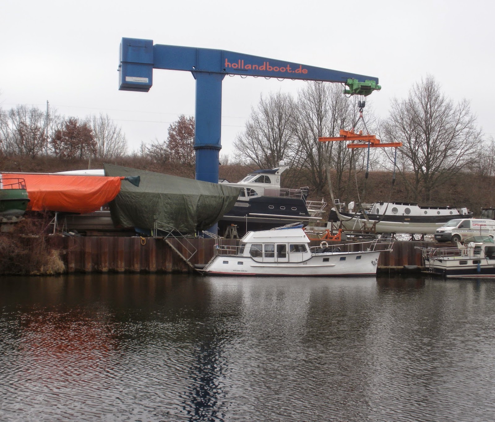 |
| Boat storage along Teltowkanal, February 2015. My photo. |
How winter-dreamy this all is. Everything here is stopped, wrapped up, asleep, waiting for summer. Boats are parked in the water, on the shore, back among the trees--looking, at times, as if they had floated up in high water and stranded among the branches.
 |
| Boat storage along Teltowkanal, February 2015. My photo. |
I'm counting bridges. This is the Outer Ring railway bridge, the fifty-fifth of the fifty-six bridges over the Teltowkanal.
 |
| Railway bridge, east end of Teltowkanal, February 2015. My photo. |
Now that we are out of the fragmented provisorium of Altglienicke, there is actually a bench by the water. Not something I have seen for miles of messy, confusedly privatized waterside:
 |
| Near end of Teltowkanal, February 2015. My photo. |
If it was not absolutely freezing outdoors, I could sit here and have some lunch and read Kierkegaard and admire the cement plant across the water. I like cement plants, though this one is terribly melancholy-looking compared to the one up on the Spree, not so far away [see Spree 6 post, June 2014].
 |
| Cement plant, Teltowkanal, February 2015. My photo. |
This one looks rather like a prison, in fact.
But here we are at the last bridge. Here is the water-junction, where the canal meets the Dahme, that fat water-street that laps against the boat-builders' sheds on Regattastrasse and carries traffic from Berlin to Poland and the Baltic.
 |
| Teltowkanal - Dahme junction, from Grünauer Brücke, February 2015. My photo. |
Bleak and Februarized as it can be. But there is a gently clattering streetcar crossing the bridge, pausing at the nearest halt (named, reasonably, Cement Works)--and I see that this line is the wonderful number 68, that runs down to Alt-Schmöckwitz, a remote corner of Berlin on a sort of peninsula where the Dahme sprawls out into lakes.
I adore the 68. It runs more or less parallel to the Dahme, and for some way it runs through the forest--no street, just the poky little tram humming through the trees, with properly signed and scheduled stops in places where you would hardly expect anyone but a wild boar to be waiting.
Well, when the leaves start coming out, we will walk down through the woods along the river to Alt-Schmöckwitz, and then we will take the 68 back again.
Now it's time to get to the S-Bahn and go home to where the city is more solid. Time to wake up the cat, toast myself against the living-room radiator, and enjoy the last outburst of bloom from my Christmas amaryllis, before the spring gets under way.
 |
| Amaryllis and cat, February 2015. Photo, M. Seadle. |
No comments:
Post a Comment