Friday, October 10, 2014

Tegeler Fließ 3

Hayfields, highrises, dune forest

<This is getting posted late: I lost some weeks to travel, flu, hosting family reunion, etc. So here it is October, and this post is about September.>

The summer does not suddenly stop here when August is over. There's no big red sign that says end of season like Labor Day in the US or the rentrée in France--the universal return to work and school and politics after the universal late-summer shutdown. In France the schools start on exactly the same day (probably the same minute) all over the country, but in Germany the (six-week) summer breaks are staggered, state by state, so that the Bavarians with school-age children may be coming back from the mountains or the beach at a very different time than the Hessians are, and the Saxons are doing it at a different time than either of them, and so on. And the schedule rotates, so that if you have an early slot one year you get a later slot the next year.

So the summer slips away uncertainly. But then there's some day when you realize--oh, but it's dark after dinner, we have to turn the lights on ... after you haven't turned on a light in what feels like months, because the daylight has lasted so long. And there's some morning when you shove the shades up and see that, for the first time in a good while, the city has a white scarf of fog over its shoulders.

So it's fall, but only just, in September. The geraniums are in tremendous form, big fluffs of red or pink flowers bursting from window boxes and balcony rails all over town. (European geraniums, not the pelargoniums that we call geraniums in the US.)


Geraniums in window boxes, Lübars, September 2014. My photo.

In Lübars, near the Tegeler Fließ, even some of the stables and barns are blooming with window-box geraniums. (Heavens, what would my father have said about blooming window-boxes on a barn? Unthinkable, in a hard-scrabble world where even putting a decent coat of paint on the barn would have seemed like getting above yourself.)

So--here we go from a bus stop in Lübars, down a side street, which dwindles promptly into a path across the meadows. How lovely this is, one of my favorite places in the world. 


Tegeler Fließtal from Lübars, September 2014. My photo.

When I was younger I liked savage and extravagant landscapes: red desert in Utah, the Rockies above timberline, and that sort of thing. The (terrifying) sublime, not the (unterrifying) beautiful, as they would have said in the eighteenth century. 

Any more, I like this: something humane and undreadful, something that looks like a place where human life could prosper.

**
But the Märkisches Viertel is still right behind us. Just look back over your shoulder and there it is, looming at the edge of the hay meadows. 

Märkisches Viertel. Photo by Lienhard Schulz, Wiki Commons.

(About the name: there is some tradition in Berlin of naming real-estate developments for other regions of Germany: the Rhenish quarter, the Bavarian quarter, the Hansa quarter, and so on. Märkisches Viertel means the Brandenburg quarter, as "Märkisch" is (obviously) the adjectival form of "Brandenburg.") 

We live seven or eight miles due south of here, so the Märkisches Viertel is the farthest thing I can see from my study window on a clear day. There it is all summer long, a toothy little white wall against the dark-blue thunderstorms that roll along the Barnim Plateau behind it; and then in the fall it gradually fades out of view in the mists. For much of the winter it's invisible, and then it comes into sight again in the spring when the fogs lift, like an animal coming out of hibernation. 

It used to have a rep--back in the later 70s and 80s--as one of the worst places in West Berlin. (Bus tours went by to give the tourists a comfortable shiver: Skyscrapers! Desolation! Crime!) It was the great local exemplar of too-big government-sponsored housing projects gone wrong; after the MV, Berlin backed off from planning gigantesque urban-renewal projects like this.

It's about the nearest you get in Berlin to things like the Robert Taylor Homes in Chicago, or Pruitt-Igoe in St. Louis, which gave public housing a terrible name and eventually were abandoned and dynamited. 

How strange it feels to have this right up against the amiably Midwestern farmscape around Lübars. The last time I was up here, a week or so ago, I was thinking that the hay needed cutting, and indeed it's all down now, drying in the September sun, smelling wonderful. (Why is the smell of fresh hay such an easy object of sentiment? Why not the smell of turnips, for example? Oh the moonlight's fair tonight along the Wabash, from the fields there comes the breath of ... What? New-mown hay, says the Indiana state song. Not turnips or cabbages. If we were horses and enjoyed eating hay, it would be more understandable that we love the fragrance--but as things are, it's a puzzle.)


Near Lübars, September 2014. My photo.

It's tremendously horsy out here in this part of Berlin, and it is obvious, as I walk, that a lot of people were riding along these paths during the weekend. You have to watch your footing on a Monday.  

**

So the Märkisches Viertel was about the closest Berlin ever got to a criminal monstrosity like the Robert Taylor Homes--and the closest you get here is so, so far away from something like Robert Taylor. The MV wasn't trash housing strung in desolation along an expressway, without green space; it wasn't intended as a place to concentrate and warehouse the poorest of the poor. It was intended as pretty good housing--affordable, not luxurious, but not a terrible place to live. 

Some of the early tenants, in the 1960s, were moved up here from Wedding [see Panke 1 post, April], while parts of the bombed-out tenement districts there were being knocked down and rebuilt. People moved from insanitary dumps into genuinely decent apartments: solidly built, well-maintained places with light, space, heat, view, and all the modern plumbing conveniences that were so notably absent in Wedding.

And some of the new tenants killed themselves--there was a scandalous wave of suicides in the MV--because we aren't white rats, we aren't always better off in cleaner cages. People need meaning as much as they need plumbing, and meaning is social, and this sort of got left out of the planning process.

People were tossed randomly into the MV, neighbors no longer next to old neighbors, and the infrastructure development didn't keep pace with the residential building. You didn't know the people who lived next to you any more, they had no meaning as people because you had no common history. There were no places to meet the people who used to be your neighbors, no replacements yet for the rickety and insanitary beer joints in Wedding. This was not a world in which low-income people were likely to have their own telephones, so you couldn't just call up your old friends and neighbors. The public transit was a little lacking out here, still, so you couldn't so easily get out of the new neighborhood. And these weren't necessarily people who had experience or skills in coping with this kind of thing. They had always been in Wedding, their parents had always been in Wedding; they knew how to cope with other hazards, but not this.

So some people killed themselves. It gave the place a bad name and perhaps skewed the mix of later-arriving tenants toward people who couldn't get an apartment elsewhere or didn't care where they lived. 

**

But things change; so many things change.  When the MV went up, the Cold War border was just on the other side of the hay meadows. I walk east now through the meadows for a bit, and then turn north--the thing that you would not have wanted to do thirty years ago--trying to get closer to the water of the Fließ again. (The information quality of my maps declines near the Brandenburg border, so this is all sort of wander-and-guess walking.) 

I know that if I go north I should come to the Mauerweg, the bike path that runs where the Berlin Wall used to be. It's about the only paved pathway hereabouts, so you know it when you meet it. I do meet it soon, and there's nice signage up along it—big boards with information about the flora and fauna, and good area maps with walker-level detail on them.

The only thing wrong with the map-boards along the path is that they don't seem to have any “you are here” marks on them. A problem for those of us who are directionally challenged and who have absolutely no clue where we are when we have got there.

Still ... I'm guessing that I should go back west along the Mauerweg for a little bit, and then I will meet the Tegeler Fließ again and be able to follow it north.

Things change, summer is over. There are apple trees along the Mauerweg; the fallen fruit rots gently on the path, making hazards for the cyclists and adding a fermented-cider note to the smell of fallen leaves in the sun. The goldenrod is massively in bloom, higher than my head, and the red berries are thick on the hawthorn bushes. Was the wall here? (Where, in this wood?) It’s hard to believe, now.  


Hawthorn along the Mauerweg, September 2014. My photo.

The Märkisches Viertel is out of sight now behind the dense woods. People in the left-wing student movement, the so-called Extra-Parliamentary Opposition (APO), had a working group in the MV in the 1970s, writing news about the place, critiquing the bad planning that went into the process of moving people up from Wedding before the infrastructure was in place, advocating for the residents who were already up there, trying to radicalize them, in some cases radicalizing themselves. 

That was a long time ago. Things change; people's lives went on from the APO in different ways. Maybe into mainstream politics (think of Joschka Fischer, who started out in the APO and ended up as Foreign Minister of Germany). Maybe into obscure ordinary life, maybe into the terrorist groups of the late 70s. It's said--I don't know if this is true--that a few of the people in the MV working group ended up with the Red Army Fraction, robbing banks and blowing up department stores and assassinating capitalists in the later 70s.

That was the first time I lived in Germany, in 1977, down in Baden-Württemberg where some of the serious terrorist action was. I remember going to the apartment of some acquaintances to see Bergman's Magic Flute film on television, and someone who was supposed to come that night was very late because he had been stopped for a long time at a roadblock while the police searched everyone's car trunks for dead capitalists.

There were four or five Chinese students at the apartment that night, one of the first groups of mainlanders sent out to study abroad. They were a bit wary and remote, all in gray Mao suits, looking out at the European world as if it were made of glass, fragile and dangerous. What did they make of Bergman, or Mozart? They couldn't tell us, maybe we didn't know how to ask.

People forget; looking back, the past seems so safe. But it wasn't. The atmosphere of armed fear that fall was like a greasy fog, catching at your throat. That fall some of the Red Army Fraction's Palestinian allies hijacked a Lufthansa jet, shot the pilot, and held the passengers hostage to pressure the German government to let the RAF leaders go. The Israelis killed the Palestinians and rescued the hostages. (But with a bit of bad luck, everyone might have been dead.) In response, the RAF killed a German capitalist. Some of the RAF leaders in prison killed themselves. Some of the righteous burghers of Stuttgart rose up and said, "Don't give those people decent funerals in our city cemetery! Throw the bodies out by the side of the road!"  Not a nice season.

**

You never know what you'll find by the side of the road. Baden-Württemberg in the late 70s was where I learned the pleasures of country walking, going through the woods from village to village, looking for Roman camps and medieval castle ruins, confusing myself with hiking maps. I was out walking one autumn day and came out of the woods to a road on a hillside, somewhere near Herrlingen I think (but when do I ever know where I am?). Down below there was a field where people seemed to have got into trouble with their farm machinery: it was smoking spectacularly, with bits of licking flame at the bottom of the smoke-pillar, and the people were running back and forth. I waited a while to see if the dry stubble-field was going to catch fire. While I was waiting I noticed an apple tree at the roadside, fountaining over a little marker, and went closer to read it. (Text, Archangel says to me, you can never resist text.) It marked the spot where Erwin Rommel killed himself in 1944, under duress, after he was accused of complicity in the plot to kill Hitler. 

**

Well, the world is not such a good place, often. But the bodies of the dead terrorists were in fact not thrown out by the side of the road in Stuttgart in 1977. The mayor of Stuttgart, Manfred Rommel, Erwin Rommel's son, said--in the face of opposition from some of his party and fury from some of the voters: Every hostility has to end somewhere. For me, in this case, it ends with death.  So bury them decently in the city cemetery, he said; and that is what was done. Bless you, Manfred Rommel.

**

So what has happened to the Märkisches Viertel, after all these years? The (city-owned) real estate companies that ran the place did gradually improve it--redesigned the public areas, created more playgrounds and green space, sponsored social events, brought in more bars and restaurants. (More bars as a solution to social problems is about as un-American a city-planning idea as you can get, given American puritanism about alcohol, but it has some things to be said for it.) 

All this pretty much worked. And so, far from being dynamited like its US counterparts, the MV sits placidly in the autumn sun, showing off its super-energy-efficient renovations and its geranium plantings. People have lived their way into it. The schools aren't the best in Berlin but they aren't the worst either. The crime rate is modest. Some people who grew up here have gone away and then come back to raise their children here. 

People rest their feet in Fountain Square, in the middle of the shopping district, watching their neighbors. It's downscale here: Woolworth's, a discount drugstore, discount electronics, McDonald's, a decent bakery. It's normal life, it's not a terrible place to live.


Brunnenplatz, Märkisches Viertel.  Photo by Pygmalion, Wiki Commons. 

**

But I need to think where I'm going. Here along the path is the Köppchensee, a place where people used to dig peat for fuel, and the water has filled in the resulting hollow. This tells me where I am, and tells me that I should be rejoining the Tegeler Fließ shortly.


Köppchensee, September 2014. My photo

And here is the Fließ again, at last, where the Mauerweg crosses it, and the horses come down to drink and the dogs to gambol when they are out for walks with their owners.

Tegeler Fließ at the Mauerweg, September 2014. My photo.

I follow the Fließ north, out of Berlin, into Brandenburg. Farther along, the path parts company from the Fließ again as the water spreads into impenetrable marsh. 

But this is a wonderful stretch, this mix of wood and meadow. It's sand-dune country; I’m glad I’m not trying to get a bicycle along some of these stretches. 
The track I’m on is partway up the side of a dune; the wetland is down at the bottom. Ah, now here is a little sandy sidetrack going up through the trees toward the top of the dune. It seems worthwhile to explore this. Maybe there’s a view at the top. And sand is, in its way, easy climbing—you don’t slip on it like rock. It’s not far. 

So here we go, what is at the top?  

Ah, an outdoor basketball court, what else? Beyond, there's a little scurf of new houses, which presumably provide the basketball players. 

**

Somewhere around here we have to get over or under a rail line--the line of the Heidekrautbahn, the Heather Train, that runs up into the lake- and heath-country north of Berlin. It appears from the map that the path and the Fließ take the same underpass, which will be nice if it’s true.  

Ah, that looks like the underpass up there. It also looks like a bit of a tight fit for my path and the Fließ both ...  

Heidekrautbahn underpass, near Schildow, September 2014. My photo.
But it does all fit--here we are on the other side, with everything in good order. The Fließ swells placidly into a small pool and my shoes are still dry.

Tegeler Fließ at the underpass, September 2014. My photo.

There is more woods-and-fields mix, and then we come out of a patch of trees to a little Brandenburg town called Schildow.

Schildow, September 2014. My photo.


There's an easy country track then for another mile or so to the S-Bahn stop at Mühlenbeck, and--since we're out of Berlin--a last goodbye to the Tegeler Fließ.

The Fließ runs past a little lake called the Kiessee, which turns out to be a popular spot on a warm afternoon, with lots of people out on--I suppose you can't call it a beach, but on the pleasant lawn that runs between the woods and the water. 

I had meant to take a photo, but under the circumstances it seemed awkward. Taking pictures of strangers always seems intrusive, and when none of them has a stitch on, it's obviously more so. The farther out you are from central Berlin, the lower the likelihood that anyone will have a swimsuit on when the weather is warm. And here it is half-summer, still; it's a lovely day.


Saturday, September 13, 2014

Tegeler Fließ 2

Rainy Day Along the Fließ

Late August was chilly and wet. I picked what was supposed to be a fine day to continue along the Tegeler Fließ, and by the time I got out to northern Berlin, the morning had curdled into rain.

Ah well, what are umbrellas for? (I say to myself as the rain settles in, in a cold and determined sort of way.) Perhaps this will not last. And we will see how waterproof this backpack really is, which currently holds my map and sandwich and Kierkegaard's Either/Or, none of which will be improved by a soaking.


Hermsdorfer See, August 2014. My photo.

This is the Hermsdorfer See, where the Tegeler Fließ widens out into a small lake. It is raining, the herons are fishing, I keep hoping for a place that will be sheltered enough that I can extract my sandwich and eat it, but no luck. (How do I take pictures and still hold the umbrella over me and the camera, since picture-taking requires both hands? Ah, the umbrella will balance on the top of my head, how cooperative of it.)

After about an hour of rain the day does clear off, quite suddenly. The outside of my backpack is streaming water, but the sandwich, the map, and Kierkegaard are all in good order inside. 

 How secret it is up here:


Tegeler Fließ, August 2014. My photo.

And how dense the greenery is. The wild morning-glories tangle through the undergrowth, knitting it together so continuously that you would almost need a machete to get through.

On some of the side-arms of the Fließ the summer pond-scum has grown so thick that it looks solid. 


Along the Tegeler Fließ, August 2014. My photo.

Not to be walked on, however.  There is a long boardwalk:


Boardwalk on Tegeler Fließ, August 2014. My photo.

And then we are out of the woods, into water meadows that the Berlin farmers (yes, there are such people) cut for hay. On the higher (dryer) ground are rye fields and mustard fields. (One time I was out here I walked through a rye field so weedy with mustard that I thought, hmm, could you harvest it all together and make mustard-flavored rye bread for ham sandwiches? ... Joke.) 

There are scattered apple trees; there is a blackberry tangle here in the edge of the woods. Hmm, these blackberries do not seem to belong to anyone, and they do look ripe ... Ouch, and they do have stinging nettles growing up in the midst of them, also.  

I look up from the blackberry tangle, over the hay-meadow, which looks as though it wants cutting; it also looks too wet to get a tractor into it this morning. What exactly is this, hovering over the meadow, some sort of white ground-mist?  No, on closer inspection, it's a meadow's-worth of white butterflies, cabbage-whites, rising and falling over the un-mown flowers. I have never seen so many butterflies at once, I think. Lovely summer superfluity.

Buttterfly near Lübars, August 2014. My photo.


We're almost at Lübars, a semi-farming village in far-northern Berlin. If you stand here and look one way, you're looking at the butterfly-meadow. If you turn around, you're looking at the high-rises of the Märkisches Viertel (big housing project, more on this next time), looming behind the nearest grassed-over sand dune. 


Märkisches Viertel near Lübars, August 2014. My photo.

Unlike the US, there's no transition here, no car-dealership-and-fast-food strip between the city and the country. You just walk out the door of your high-rise or away from the bus stop into the meadows and the fields. (We have car dealerships and fast-food joints in Berlin, of course, but they don't make a big anti-pedestrian minefield around the city.)

How lovely this is. 

On the one hand, I could go a few more miles and pick up a bus on the next big north-south street; or I could turn into Lübars and pick up a bus there. Hmm ... is this sunshine going to last? Maybe, but I have got water down the back of my neck. And the Lübars bus is more fun. I remember last year, when I was out here in early summer, it seemed that anywhere I got on or off the route further west, some local florist or nursery had bedding plants stacked up for sale by the bus stop.

It was a good opportunity to learn German flower names.  Inspect the display while waiting for the bus ... Here were flats of "cavalrymen's buttons" (Husarenknöpfchen): this makes sense, they're little yellow flowers like gold buttons. Flats of "men's faithfulness" (Männertreu), so called because the flowers don't last (come, this is cynical). A few pots of "girls' eyes" (Mädchenaugen)--yellow flowers, some kind of coreopsis ... puzzling name, I never figured that one out. 

Time to go home, dry off, and start again another day. 

Tegeler Fließ Map

A friend suggested including maps of these waterways, so here is one for the Tegeler Fließ.  

The green areas below are forest, the gray are built-up areas, and the cream-colored space is open land (fields, meadows, etc.).  The Tegeler Fließ flows out of the Mühlenbecker See up in Brandenburg (upper part of the map) and into the Tegeler See in the northwest corner of Berlin (lower left-hand corner). 

The Berlin-Brandenburg border shows as a pinkish line (Hermsdorf and Lübars on the Berlin side of it, and Glienicke and Schildow on the Brandenburg side). 


Map by A. Fiedler, Wiki Commons.

Monday, September 1, 2014

French Interlude: Confluence of Rivers

In mid-August Archangel had a week of meetings in Lyon, and I tagged along. We stayed in a neighborhood called Confluence, which is where the rivers Saône and Rhône come together after flowing parallel for some miles through center city, eight or ten streets apart. Potentially a good place to walk by the water.

The Rhône river in central Lyon, August 2014. My photo.

I had never been in Lyon before. It's a long time since I was last in France at all, fifteen years, maybe. It's even longer since I was first in France, almost forty years ago. 

It's a tremendous thing, being in France for the first time. i don't think Germany makes the same initial impression. (When I arrived in Germany it was my first time on the European continent, I had missed all my connections, and it was one in the morning. I was in a cheap hotel recommended by a couple of friendly inebriates on the street, and my only specific memory is of looking in dismay at the first featherbed I had ever met, and thinking, how the hell is this bedding supposed to operate?) 

France was different. It was late September or early October, I'd been on a cheap, packed night train from Munich and got out at Avignon hours before dawn, in order to catch a morning train deeper into rural Provence to meet a friend. [Molly, this was your mother, a couple of months before you were born, so you were sort of along on the later part of this venture.] I dozed in the station until it was full day, and then walked into center city in the rainy morning, in search of breakfast.

How different the streets looked here, how different they sounded and smelled! There were tall houses with mansard roofs in long rows, there were arcs of big umbrellas filling the street, cutting the line of sight. (I know this, it's a painting! It's a provincial version of the Paris Street, Rainy Day at the Chicago Art Institute!) Heavy metal shutters started to creak up over shop windows. There was French-coffee smell in the autumn rain, French-bread smell, the faintly nauseating smell of raw meat hanging in the open at the butcher's. 

**

France is still France. The hotels are still called the Grand Hotel of Peace, or the Hotel of the Theatrical Performers, or the Grand Hotel of the Emperor. (Hotels in Germany, as in the US, are called the Best Western Hamburg or the Westin Berlin.) The barrier machines on the Metro still suck up and spit out the little cardboard tickets with startling aggression. 

The streetscape still looks like a painting. In fact it still looks like the same painting. Not-quite-Paris street, not-quite-rainy day.

Place des Jacobins, Lyon, August 2014.  My photo.

You can get a lot of entertainment out of reading English Wikipedia articles about provincial France, which tend to be translated from the original by dashing Francophones equipped with a dictionary and not much else. In the case of the fountain in the Place des Jacobins (above), we learn that the funds for the sculptural group were "donated by a tapestry." The sculpture itself was "melted by Barbezat," and the figures on the fountain are four local artists "represented with their respective clothes." 

The figures are supported by several water-nymphs, represented without their respective clothes, each clutching a spouting fish to her bosom. 

Ah, Germany is not like this. There is a shortage of naked water nymphs in Berlin, a shortage of classical and allegorical figures of all sorts (except on the east end of Unter den Linden, which is half-lost under construction work). How lovely the fountains are here, how clean and silver-sparkly the water looks. Our unsculptured and empty neighborhood fountain in Berlin tends to be a trap for dirt and fast-food wrappers.   

**

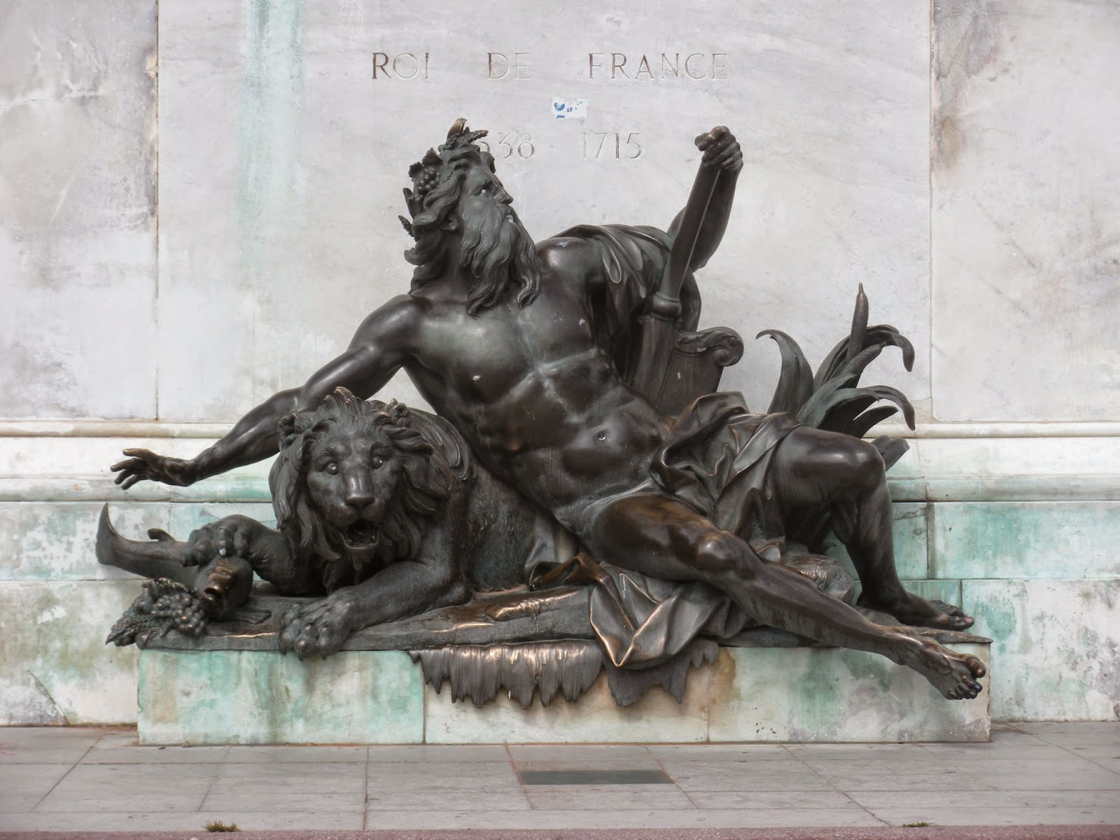
The equestrian statue of Louis XIV in the next square south of Place des Jacobins (Place Bellecour) has an allegorical figure of the Rhône on one side of the base:


The Rhone; figure on fountain in Place Bellecour, Lyon, August 2014. My photo.

And an allegorical figure of the Saône on the other side. 


The Saône: figure on fountain, Place Bellecour, Lyon, August 2014. My photo.

I have never seen an allegorical representation of the Spree or the Havel. One may yet surprise me, of course.

**

We complain occasionally about changes of street names in Berlin, but street-naming is far more volatile in France. The Place des Jacobins used to be Place Confort, then Place des Jacobins (for the Dominican church nearby), then the Place de la Fraternité (revolutionary France), then the Place de la Préfecture (less revolutionary), and the Place de l'Impératrice (for Napoleon III's wife?), and then the Place des Jacobins again when there was no longer an empress. It reminded me of an old joke of Archangel's, in which the Rue du Roi is renamed the Rue de la République after the Revolution, and then the Rue de l'Empereur when Napoleon takes over, and then the Rue du Roi again when Louis XVIII comes back, and then the Rue du Président in the Second Republic, and then the Rue de l'Empereur again; and finally the locals get fed up with the name-changing and dig in their heels and rename the street--finally, unchangeably--the Rue du Pouvoir du Chef-Exécutif.

The renaming in Berlin usually has a shorter history than this. Dorotheenstraße in Berlin (Archangel's office address) was named for the person on the left below, the seventeenth-century princess Dorothea Sophie von Schleswig-Holstein-Sonderburg-Glücksburg [see Spree 7 post in June for more on the Glücksburg family]. In East-German times it was renamed Clara-Zetkin-Straße, for the person on the right. (What a wonderful picture. Is there a place for such formidable frumps in France? Perhaps not, which is one of the less comforting things about France. I would love to grow old looking like Georgia O'Keefe, but I'm more likely to grow old looking like Clara Zetkin ...)

Clara Zetkin member of the 
German Parliament, 1920s
Photo, Wiki Commons. 
Portrait of Dorothea Sophie,
Electress of Brandenburg.
 From Wiki Commons.

With the end of East Germany, the street became Dorotheenstraße again. End of socialist frumpery, return of (slight, flat-chested) historical elegance. 

Place names hardly ever change like this in the US, which likes to keep its street-names neutral. You don't need to rename Main Street--let alone Second Avenue--when politics change. (Very occasionally the US has a street name that becomes politically embarrassing, like Balbo Avenue in Chicago. Balbo was Mussolini's air minister, living there is almost like having an address on Hermann Göring Drive. But the US tends to let sleeping histories lie. Admittedly, there was a small movement a few years ago to rename Balbo Avenue for the physicist Enrico Fermi, or possibly for a local baseball player. (The U of Chicago blog, arguing for Fermi, acknowledged the opposing argument that Balbo was not the worst of Fascists, and added, "But being the world’s nicest fascist is a little like being the world’s biggest Chihuahua; you’re setting the bar pretty low.") It's still Balbo Avenue.)

Passing thought ... Does anyone else feel uncomfortable in a place like Greeley, in Colorado, which doesn't have street names for the most part, just numbers? 1st Avenue, 2nd Avenue, and so forth run north-south, and 1st Street, 2nd Street, etc. run east-west. It seems excessively abstract, but maybe the system grows on you if you live there. At least you know where an address is when you see it, and you know how to get there. A name like W. 9th St. gives you more information, in this sense, than a name like Roosevelt Drive does. (And more occasions to ponder the possible differences between information and meaning.) 

The urban-planning problem, of course, is what happens when the city expands beyond 1st Avenue and 1st Street, on the opposite side from 2nd. You could follow the real number line and have Negative 1st Ave., Negative 2nd Ave., and so on, to the east of Positive First Avenue. But I suppose this might not be popular. East of 1st Ave. Greeley has started using entire words for street names. (Short words. Ash. Birch.) But north of 1st St. the city continues to be very frugal in the amount of meaning it dispenses to create a place-name. The street names are just individual letters plus the E. or W. indicator. So you can have an address on W.C. Street.  If you want.)

**

Well, let's get out of the central streets in Lyon and onto a river....  Hmm, it turns out that we can't do this on the Rhône side of the Confluence neighborhood, because one of the busier highways in France roars along the riverbank. It appears that, as a pedestrian, you can't even get close. (This is the so-called Freeway of the Sun, the Autoroute du Soleil, which takes Parisians down to the Mediterranean for their beach vacations in August.) 

Farther north in the city, however, we can get to the Rhône, which welcomes us thus:


Danger! Eating fish caught in the Rhône is forbidden.  My photo, August 2014.


Cross the center-city peninsula to the Saône, and you see a similar sign. 

This is a bit shocking--after all, we can eat the fish from the Havel and the Spree, we can even eat the fish from the Rhine (in moderation, perhaps). The Rhine was the sewer of Europe forty years ago, but it's been cleaned up a lot. The Rhône has not been cleaned up a lot. (PCB levels in the Rhône fish are as much as forty times the allowed maximums.) 

One must admit that the Rhine fisheries aren't what they were either, though for other reasons. Invasive giant catfish, which get as big as three hundred pounds, have been taking out the salmon and the trout. One of these can give a fisherman quite a run for his money, I have read. But I'm not sure that big-time sport fishing is coming to western Germany soon. It's so much less Hemingwayesque to battle a big fish in the gray chill on the Rhine, in the shadow of the aspirin factory, than to do it in the sun off some Caribbean island.

**

It becomes conspicuous here that the environmental movement has been weaker in France than in Germany. Hello, where's the broad-range recycling? Where are the bicyclists? Where's the renewable energy? France, which has way more sun, has about a tenth of the solar generating capacity that Germany does. (We had a peak day this summer when 75% of the power in use in Germany was coming from renewables--which beats buying gas from the Russians--but of course the winter is going to be a different story....) 

Things are changing in France, but it's slow. The information sheet in our hotel says, Please don't drive your car in Lyon. Walk or bicycle or take public transit. (That is, the French side of the sheet says this; the English side just says Walk, for some reason.) Along the portions of the rivers not occupied by highway are some pleasant promenade stretches with bicycle paths, and there are conspicuous public bike-rental places--but much of this looks recent, not yet a settled part of local life. The people on bicycles are young and look like they're engaging in le sport; they're not the all-ages crowd that spins through the city on bikes as part of daily life in northern Europe. 

Geography has a bit to do with the absence of bicyclists, of course. Northern Europe is flat. Lyon, like many cities farther south, has some steep and rocky stretches. 

Street rises above street ...


Along the Saône, Lyon, August 2014.  My photo.


Tower above tower:


St Jean cathedral (below) and Fourvière basilica (on hill), Lyon, August 2014. My photo.


But then, realistically, if you live here, how often do you actually have to go to the top of Fourvière hill? Much of the population lives and works on the flat ....

I look at this and think: The world we grew up in was strange. The area around the cathedral in Lyon is one of the largest Renaissance cityscape ensembles in Europe (see photo below for some interior detail). And in the 1960s it seemed like a good idea to the city government to run a bulldozer through it and replace it with a freeway ramp. 

Happily, this project did not happen (and central Lyon has done perfectly well without the freeway ramp). But what were people thinking? 


Cours Philibert Delorme, 16th century, Lyon.  Photo by Blaise Laustriat, Wiki Commons.
**

With an insufficient sense of history, you can suppose that urban-planning projects are typically bad, and that most public construction works are cases of paving paradise and putting up a parking lot. But the 1960s and 70s were unusually inhumane. The 1920s and 30s often did better. (Our neighborhood in Berlin is a big 1950s public housing project, and it's one of the pleasanter places I've lived in sixty-plus years.) A number of the low-income housing projects that were built in Berlin between the wars are now UNESCO World Heritage sites, and so is a similar one in Lyon.

The Lyon site is in a neighborhood called États-Unis, the United States. (Just at the point when the city was starting to de-slum the neighborhood and wanted to relabel it, the US entered World War I; hence the name.) It's typical 1920s modernist city planning: solid, attractive basic housing, plenty of light and green space. It's still a fairly low-income neighborhood (lots of African immigrants), but it's not a slum. It shows itself off with a museum about the project and its planner, Tony Garnier, and it is home to a (relatively recent) mural project called the ideal city, in which the ends of the apartment houses have been painted to look, for example, like this:


In États-Unis, Lyon, August 2014

Along one street there are signs above the entry doors bearing conceptual-art sorts of statements like: 

     My first name means September.
       
     People get used to certain things in spite of themselves.

     Victor Hugo is dead.

     In my village the mountain had the shape of a boat.

     The big heads say, We are the ones who decide.


In États-Unis, Lyon, August 2014. My photo.


Very stylish (of course, we're in France.)

**
We're in the part of Europe from which Germany has often looked terribly unhousebroken. It wasn't even Roman! Nothing but swamp up here in classical times! And Lyon, in contrast, was very Roman--the biggest Roman city north of the Alps. There was an amphitheater on Fourvière hill that could hold ten or eleven thousand people:


Roman amphitheater, Lyon, August 2014. My photo.


When people up around the Baltic were barely past worshipping three-headed Triglav and four-headed Svetovid, France was starting to build stuff like this:


Church of St Nizier, Lyon, August 2014. My photo.


Even when the Baltic coastlands were Christianized, they didn't build like this. We have red brick, we have lumpy fieldstone, we don't have this white-lace Gothic in the far north. 

I ask myself now: when we were starting college and took Western Civ or Arts and Ideas or whatever the local institution called it, how much of what we were shown (how much of what was amazing to us, if all we knew was prairies and strip malls) was this sort of thing: a Roman aqueduct marching across Provence; Gothic cathedrals; Versailles; Liberty Leading the People (with the intention of trashing Versailles if the People had been sober enough to walk that far); Van Gogh painting starry nights over the Rhône. How much of it had the subtext, Isn't France beautiful?  Look, look ...

**

The murals--at least some of them--in États-Unis are by an artists' cooperative called Cité-Création which has done murals elsewhere in Lyon and around the world. 

Mural, central Lyon, August 2014. My photo.

One of their biggest projects is on the exterior of the Carrefour supermarket in Shanghai, an immense mural that packs in all the visual cliches of French culture:  here is the Eiffel tower, here are the tall Paris houses, here is Sacré-Coeur. Here is a traditional bakery and someone coming out with a baguette. 

More than a little kitschy, and dubiously relevant in the middle of Shanghai. But apparently people are taken with it (and this isn't anything special about Shanghai, I think it would work almost anywhere in the world); it's probably effective advertising for Carrefour. How have the French snookered us all into being so charmed by the sight of a French person carrying a baguette? 

It's difficult to imagine one of the German supermarket chains tempting international customers inside with a mural depicting a German holding a Landbrot. (One of those wonderful-tasting dark loaves which, if it fell on your foot, would probably break it.) Hard to imagine Walmart adorning itself with a fresco of people loading groceries into their SUVs in the Walmart parking lot. 

**

Back in Berlin, at Tegel Airport, my suitcase arrives but Archangel's does not. Tegel (which was built for about a tenth of the traffic that now goes through it) is sinking under the weight of summer tourism. We go to the lost-luggage office, and Archangel, who travels a lot, says, exasperated, This happens so often. The tired woman behind the counter says, Yes, yes, I recognize your face. 

He says, There was even a priority flag on the suitcase. It seems as though my bag gets lost even more often when there's a priority flag on it than when there isn't. 

If this were still Lyon, the woman would probably say that she was desolated, and say so with such charm that one could do nothing but smile. This is not Lyon, however, and the woman behind the counter says sturdily, If you think so, then don't have a priority flag put on your bag. This is Germany, we do not answer with charm, we answer with reason.


The bus from the airport to Moabit is near-lethally packed. Public transit is a social site in the German sense, however, meaning that we are all responsible for each other and must make the best of the situation together. (I did not have this sense on public transit in Lyon, but what do I know, it was a small sample.) There are murmurs and shuffles and calls: younger people give up seats to older people, mislaid children and spouses are passed through the crowd to the people who are looking for them, visitors who are unsure where they are going are shepherded out at their stops. 

We struggle out at our stop, sweating like sauna participants, and drag ourselves up to the apartment, with its fine view of the treetops (so much more green here!) and power plants and rail lines. It doesn't look like a painting. It's not beautiful--at least not the same way, it's not Western Civ. But it's good to be back.