Monday, September 1, 2014

French Interlude: Confluence of Rivers

In mid-August Archangel had a week of meetings in Lyon, and I tagged along. We stayed in a neighborhood called Confluence, which is where the rivers Saône and Rhône come together after flowing parallel for some miles through center city, eight or ten streets apart. Potentially a good place to walk by the water.

The Rhône river in central Lyon, August 2014. My photo.

I had never been in Lyon before. It's a long time since I was last in France at all, fifteen years, maybe. It's even longer since I was first in France, almost forty years ago. 

It's a tremendous thing, being in France for the first time. i don't think Germany makes the same initial impression. (When I arrived in Germany it was my first time on the European continent, I had missed all my connections, and it was one in the morning. I was in a cheap hotel recommended by a couple of friendly inebriates on the street, and my only specific memory is of looking in dismay at the first featherbed I had ever met, and thinking, how the hell is this bedding supposed to operate?) 

France was different. It was late September or early October, I'd been on a cheap, packed night train from Munich and got out at Avignon hours before dawn, in order to catch a morning train deeper into rural Provence to meet a friend. [Molly, this was your mother, a couple of months before you were born, so you were sort of along on the later part of this venture.] I dozed in the station until it was full day, and then walked into center city in the rainy morning, in search of breakfast.

How different the streets looked here, how different they sounded and smelled! There were tall houses with mansard roofs in long rows, there were arcs of big umbrellas filling the street, cutting the line of sight. (I know this, it's a painting! It's a provincial version of the Paris Street, Rainy Day at the Chicago Art Institute!) Heavy metal shutters started to creak up over shop windows. There was French-coffee smell in the autumn rain, French-bread smell, the faintly nauseating smell of raw meat hanging in the open at the butcher's. 

**

France is still France. The hotels are still called the Grand Hotel of Peace, or the Hotel of the Theatrical Performers, or the Grand Hotel of the Emperor. (Hotels in Germany, as in the US, are called the Best Western Hamburg or the Westin Berlin.) The barrier machines on the Metro still suck up and spit out the little cardboard tickets with startling aggression. 

The streetscape still looks like a painting. In fact it still looks like the same painting. Not-quite-Paris street, not-quite-rainy day.

Place des Jacobins, Lyon, August 2014.  My photo.

You can get a lot of entertainment out of reading English Wikipedia articles about provincial France, which tend to be translated from the original by dashing Francophones equipped with a dictionary and not much else. In the case of the fountain in the Place des Jacobins (above), we learn that the funds for the sculptural group were "donated by a tapestry." The sculpture itself was "melted by Barbezat," and the figures on the fountain are four local artists "represented with their respective clothes." 

The figures are supported by several water-nymphs, represented without their respective clothes, each clutching a spouting fish to her bosom. 

Ah, Germany is not like this. There is a shortage of naked water nymphs in Berlin, a shortage of classical and allegorical figures of all sorts (except on the east end of Unter den Linden, which is half-lost under construction work). How lovely the fountains are here, how clean and silver-sparkly the water looks. Our unsculptured and empty neighborhood fountain in Berlin tends to be a trap for dirt and fast-food wrappers.   

**

The equestrian statue of Louis XIV in the next square south of Place des Jacobins (Place Bellecour) has an allegorical figure of the Rhône on one side of the base:
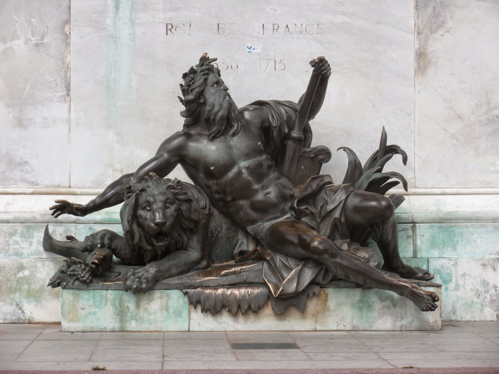

The Rhone; figure on fountain in Place Bellecour, Lyon, August 2014. My photo.

And an allegorical figure of the Saône on the other side. 


The Saône: figure on fountain, Place Bellecour, Lyon, August 2014. My photo.

I have never seen an allegorical representation of the Spree or the Havel. One may yet surprise me, of course.

**

We complain occasionally about changes of street names in Berlin, but street-naming is far more volatile in France. The Place des Jacobins used to be Place Confort, then Place des Jacobins (for the Dominican church nearby), then the Place de la Fraternité (revolutionary France), then the Place de la Préfecture (less revolutionary), and the Place de l'Impératrice (for Napoleon III's wife?), and then the Place des Jacobins again when there was no longer an empress. It reminded me of an old joke of Archangel's, in which the Rue du Roi is renamed the Rue de la République after the Revolution, and then the Rue de l'Empereur when Napoleon takes over, and then the Rue du Roi again when Louis XVIII comes back, and then the Rue du Président in the Second Republic, and then the Rue de l'Empereur again; and finally the locals get fed up with the name-changing and dig in their heels and rename the street--finally, unchangeably--the Rue du Pouvoir du Chef-Exécutif.

The renaming in Berlin usually has a shorter history than this. Dorotheenstraße in Berlin (Archangel's office address) was named for the person on the left below, the seventeenth-century princess Dorothea Sophie von Schleswig-Holstein-Sonderburg-Glücksburg [see Spree 7 post in June for more on the Glücksburg family]. In East-German times it was renamed Clara-Zetkin-Straße, for the person on the right. (What a wonderful picture. Is there a place for such formidable frumps in France? Perhaps not, which is one of the less comforting things about France. I would love to grow old looking like Georgia O'Keefe, but I'm more likely to grow old looking like Clara Zetkin ...)

Clara Zetkin member of the 
German Parliament, 1920s
Photo, Wiki Commons. 
Portrait of Dorothea Sophie,
Electress of Brandenburg.
 From Wiki Commons.

With the end of East Germany, the street became Dorotheenstraße again. End of socialist frumpery, return of (slight, flat-chested) historical elegance. 

Place names hardly ever change like this in the US, which likes to keep its street-names neutral. You don't need to rename Main Street--let alone Second Avenue--when politics change. (Very occasionally the US has a street name that becomes politically embarrassing, like Balbo Avenue in Chicago. Balbo was Mussolini's air minister, living there is almost like having an address on Hermann Göring Drive. But the US tends to let sleeping histories lie. Admittedly, there was a small movement a few years ago to rename Balbo Avenue for the physicist Enrico Fermi, or possibly for a local baseball player. (The U of Chicago blog, arguing for Fermi, acknowledged the opposing argument that Balbo was not the worst of Fascists, and added, "But being the world’s nicest fascist is a little like being the world’s biggest Chihuahua; you’re setting the bar pretty low.") It's still Balbo Avenue.)

Passing thought ... Does anyone else feel uncomfortable in a place like Greeley, in Colorado, which doesn't have street names for the most part, just numbers? 1st Avenue, 2nd Avenue, and so forth run north-south, and 1st Street, 2nd Street, etc. run east-west. It seems excessively abstract, but maybe the system grows on you if you live there. At least you know where an address is when you see it, and you know how to get there. A name like W. 9th St. gives you more information, in this sense, than a name like Roosevelt Drive does. (And more occasions to ponder the possible differences between information and meaning.) 

The urban-planning problem, of course, is what happens when the city expands beyond 1st Avenue and 1st Street, on the opposite side from 2nd. You could follow the real number line and have Negative 1st Ave., Negative 2nd Ave., and so on, to the east of Positive First Avenue. But I suppose this might not be popular. East of 1st Ave. Greeley has started using entire words for street names. (Short words. Ash. Birch.) But north of 1st St. the city continues to be very frugal in the amount of meaning it dispenses to create a place-name. The street names are just individual letters plus the E. or W. indicator. So you can have an address on W.C. Street.  If you want.)

**

Well, let's get out of the central streets in Lyon and onto a river....  Hmm, it turns out that we can't do this on the Rhône side of the Confluence neighborhood, because one of the busier highways in France roars along the riverbank. It appears that, as a pedestrian, you can't even get close. (This is the so-called Freeway of the Sun, the Autoroute du Soleil, which takes Parisians down to the Mediterranean for their beach vacations in August.) 

Farther north in the city, however, we can get to the Rhône, which welcomes us thus:


Danger! Eating fish caught in the Rhône is forbidden.  My photo, August 2014.


Cross the center-city peninsula to the Saône, and you see a similar sign. 

This is a bit shocking--after all, we can eat the fish from the Havel and the Spree, we can even eat the fish from the Rhine (in moderation, perhaps). The Rhine was the sewer of Europe forty years ago, but it's been cleaned up a lot. The Rhône has not been cleaned up a lot. (PCB levels in the Rhône fish are as much as forty times the allowed maximums.) 

One must admit that the Rhine fisheries aren't what they were either, though for other reasons. Invasive giant catfish, which get as big as three hundred pounds, have been taking out the salmon and the trout. One of these can give a fisherman quite a run for his money, I have read. But I'm not sure that big-time sport fishing is coming to western Germany soon. It's so much less Hemingwayesque to battle a big fish in the gray chill on the Rhine, in the shadow of the aspirin factory, than to do it in the sun off some Caribbean island.

**

It becomes conspicuous here that the environmental movement has been weaker in France than in Germany. Hello, where's the broad-range recycling? Where are the bicyclists? Where's the renewable energy? France, which has way more sun, has about a tenth of the solar generating capacity that Germany does. (We had a peak day this summer when 75% of the power in use in Germany was coming from renewables--which beats buying gas from the Russians--but of course the winter is going to be a different story....) 

Things are changing in France, but it's slow. The information sheet in our hotel says, Please don't drive your car in Lyon. Walk or bicycle or take public transit. (That is, the French side of the sheet says this; the English side just says Walk, for some reason.) Along the portions of the rivers not occupied by highway are some pleasant promenade stretches with bicycle paths, and there are conspicuous public bike-rental places--but much of this looks recent, not yet a settled part of local life. The people on bicycles are young and look like they're engaging in le sport; they're not the all-ages crowd that spins through the city on bikes as part of daily life in northern Europe. 

Geography has a bit to do with the absence of bicyclists, of course. Northern Europe is flat. Lyon, like many cities farther south, has some steep and rocky stretches. 

Street rises above street ...


Along the Saône, Lyon, August 2014.  My photo.


Tower above tower:


St Jean cathedral (below) and Fourvière basilica (on hill), Lyon, August 2014. My photo.


But then, realistically, if you live here, how often do you actually have to go to the top of Fourvière hill? Much of the population lives and works on the flat ....

I look at this and think: The world we grew up in was strange. The area around the cathedral in Lyon is one of the largest Renaissance cityscape ensembles in Europe (see photo below for some interior detail). And in the 1960s it seemed like a good idea to the city government to run a bulldozer through it and replace it with a freeway ramp. 

Happily, this project did not happen (and central Lyon has done perfectly well without the freeway ramp). But what were people thinking? 


Cours Philibert Delorme, 16th century, Lyon.  Photo by Blaise Laustriat, Wiki Commons.
**

With an insufficient sense of history, you can suppose that urban-planning projects are typically bad, and that most public construction works are cases of paving paradise and putting up a parking lot. But the 1960s and 70s were unusually inhumane. The 1920s and 30s often did better. (Our neighborhood in Berlin is a big 1950s public housing project, and it's one of the pleasanter places I've lived in sixty-plus years.) A number of the low-income housing projects that were built in Berlin between the wars are now UNESCO World Heritage sites, and so is a similar one in Lyon.

The Lyon site is in a neighborhood called États-Unis, the United States. (Just at the point when the city was starting to de-slum the neighborhood and wanted to relabel it, the US entered World War I; hence the name.) It's typical 1920s modernist city planning: solid, attractive basic housing, plenty of light and green space. It's still a fairly low-income neighborhood (lots of African immigrants), but it's not a slum. It shows itself off with a museum about the project and its planner, Tony Garnier, and it is home to a (relatively recent) mural project called the ideal city, in which the ends of the apartment houses have been painted to look, for example, like this:


In États-Unis, Lyon, August 2014

Along one street there are signs above the entry doors bearing conceptual-art sorts of statements like: 

     My first name means September.
       
     People get used to certain things in spite of themselves.

     Victor Hugo is dead.

     In my village the mountain had the shape of a boat.

     The big heads say, We are the ones who decide.


In États-Unis, Lyon, August 2014. My photo.


Very stylish (of course, we're in France.)

**
We're in the part of Europe from which Germany has often looked terribly unhousebroken. It wasn't even Roman! Nothing but swamp up here in classical times! And Lyon, in contrast, was very Roman--the biggest Roman city north of the Alps. There was an amphitheater on Fourvière hill that could hold ten or eleven thousand people:


Roman amphitheater, Lyon, August 2014. My photo.


When people up around the Baltic were barely past worshipping three-headed Triglav and four-headed Svetovid, France was starting to build stuff like this:


Church of St Nizier, Lyon, August 2014. My photo.


Even when the Baltic coastlands were Christianized, they didn't build like this. We have red brick, we have lumpy fieldstone, we don't have this white-lace Gothic in the far north. 

I ask myself now: when we were starting college and took Western Civ or Arts and Ideas or whatever the local institution called it, how much of what we were shown (how much of what was amazing to us, if all we knew was prairies and strip malls) was this sort of thing: a Roman aqueduct marching across Provence; Gothic cathedrals; Versailles; Liberty Leading the People (with the intention of trashing Versailles if the People had been sober enough to walk that far); Van Gogh painting starry nights over the Rhône. How much of it had the subtext, Isn't France beautiful?  Look, look ...

**

The murals--at least some of them--in États-Unis are by an artists' cooperative called Cité-Création which has done murals elsewhere in Lyon and around the world. 

Mural, central Lyon, August 2014. My photo.

One of their biggest projects is on the exterior of the Carrefour supermarket in Shanghai, an immense mural that packs in all the visual cliches of French culture:  here is the Eiffel tower, here are the tall Paris houses, here is Sacré-Coeur. Here is a traditional bakery and someone coming out with a baguette. 

More than a little kitschy, and dubiously relevant in the middle of Shanghai. But apparently people are taken with it (and this isn't anything special about Shanghai, I think it would work almost anywhere in the world); it's probably effective advertising for Carrefour. How have the French snookered us all into being so charmed by the sight of a French person carrying a baguette? 

It's difficult to imagine one of the German supermarket chains tempting international customers inside with a mural depicting a German holding a Landbrot. (One of those wonderful-tasting dark loaves which, if it fell on your foot, would probably break it.) Hard to imagine Walmart adorning itself with a fresco of people loading groceries into their SUVs in the Walmart parking lot. 

**

Back in Berlin, at Tegel Airport, my suitcase arrives but Archangel's does not. Tegel (which was built for about a tenth of the traffic that now goes through it) is sinking under the weight of summer tourism. We go to the lost-luggage office, and Archangel, who travels a lot, says, exasperated, This happens so often. The tired woman behind the counter says, Yes, yes, I recognize your face. 

He says, There was even a priority flag on the suitcase. It seems as though my bag gets lost even more often when there's a priority flag on it than when there isn't. 

If this were still Lyon, the woman would probably say that she was desolated, and say so with such charm that one could do nothing but smile. This is not Lyon, however, and the woman behind the counter says sturdily, If you think so, then don't have a priority flag put on your bag. This is Germany, we do not answer with charm, we answer with reason.


The bus from the airport to Moabit is near-lethally packed. Public transit is a social site in the German sense, however, meaning that we are all responsible for each other and must make the best of the situation together. (I did not have this sense on public transit in Lyon, but what do I know, it was a small sample.) There are murmurs and shuffles and calls: younger people give up seats to older people, mislaid children and spouses are passed through the crowd to the people who are looking for them, visitors who are unsure where they are going are shepherded out at their stops. 

We struggle out at our stop, sweating like sauna participants, and drag ourselves up to the apartment, with its fine view of the treetops (so much more green here!) and power plants and rail lines. It doesn't look like a painting. It's not beautiful--at least not the same way, it's not Western Civ. But it's good to be back.


Thursday, August 21, 2014

Tegeler Fließ 1

Belly View, Fat Marie, and Humboldt, Kansas

Having walked the main branch of the Spree from one end of Berlin to the other this summer [see previous posts], I want to go back and explore some side-branches and tributaries on the east side of the city. But it will be easier to do this later, when the east-central chunk of the Stadtbahn re-opens after a bout of track replacement. (Summer is transit-construction season here, as it is highway-construction season in the US.) And I can’t let the season get to its end without walking at least the Berlin section of the Tegeler Fließ, as I have done every summer for several years. So we’re going to shift location for a couple of weeks.

Tegeler Fließ, June 2014.  Photo, EbeWi, Wiki Commons.

Unlike many of the smaller streams in Berlin, the Tegeler Fließ has not been engineered into a die-straight drain. It’s still a meandering wetland, full of cuckoos and nightingales, fish and fish-otters, marsh-orchid and snakeroot, carthusian pinks and devil's-bit (the last is a species of scabiosa, for the gardening-minded among you). The oldest traces of human settlement in Berlin are here: Stone Age people hunted reindeer along the stream, and Bronze Age people settled in little fisher-hunter-gatherer communities here. 

According to the anthropologists, it was a relatively easy life. Especially where there were fish, hunter-gatherers didn't have to work nearly as hard for a living as agriculturalists did later. The advantage of agriculture was not that it was an easier life, it was that you could support more people in the same space--and of course have more stuff, because you didn't need to move around as much. (But then, once you started supporting more people, you were more or less stuck with it, and so here we all are with lots of stuff and without the leisure of self-respecting Neanderthals.)

The Berlin section of the Tegeler Fließ was the East-West border in Cold War days, but it was one of the less tense stretches of the border. Numerous people were shot and/or drowned in the Spree and the Havel, and a few in the Berlin-Spandauer Schifffahrtskanal, trying to make it from East to West; but so far as it is possible to tell from the casualty lists in places like Wikipedia, no one died in the Tegeler Fließ. The Wall itself was set well back, on the north side of the wetland where the ground was solid enough to build on, and the wetland was pretty much left to itself by both sides. 

The Fließ starts up in the Barnim Plateau north of Berlin and collects a portion of the western plateau waters to bring them into the river Havel here at the Tegeler See--one of the widest of the wide spots of the Havel, the chain of lakes you see on the western edge of Berlin when you fly in from that direction. 

Tegeler See. Photo by Tilman Kluge, Wiki Commons.

I think that the first time in my life I ever heard a live cuckoo was out here. Because I was near a cluster of houses, I thought it was a cuckoo clock in some open-windowed living room. But it wasn’t. (The last time I was up here, last summer, I was sitting on a bench by the water eating a sandwich and thought my phone was ringing, but it turned out to be a duck announcing its interest in a share of the sandwich. And it's not so much that I have a bizarre ringtone, it was more that it was a bizarre duck.)

**

To substitute for the S-Bahn trains that are not running because of the track replacement, there have been herds of buses, vast as bison herds on the plains, lumbering back and forth beside the silent S-Bahn routes since mid-July. The buses are rented, and the drivers often appear to be non-native-German speakers and/or non-Berliners, who make heavy weather of announcing the station stops. 

Our neighborhood station, Bellevue, which is pronounced in a terribly conscientiously French manner on the S-Bahn announcements, comes out sounding like Belly View on the bus.

So I hop the bus from Belly View to Friedrichstrasse and then take the S1 northbound to Tegel. (This is Tegel the sub-district, a component of Berlin, not Tegel the airport, which is at the southern edge of the sub-district.) The district up here is Reinickendorf, probably named for its thirteenth century developer (Lokator is the medieval technical term), one Reinhard. But somehow the name got twisted from Reinhard into Reinecke--for Reinecke Fuchs, Reynard the Fox, the trickster figure in medieval fables. (Did trickster figures and real estate developers seem similar in the Middle Ages?) Hence the red fox on the district coat of arms:

Reinickendorf arms.  Wiki Commons. 

** 

It’s late summer now, the abundant green of the city is darker than in May—sometimes dusty, but not today after a week of warm rains. What a scruffy little wilderness it is along the tracks going north from Friedrichstrasse. Around the Humboldthain stop (Humboldt Grove--we have to talk about the Humboldts later) there is mullein and something that looks like fireweed in bloom—tall yellow spikes and tall purple spikes beside the tracks, almost brushing the windows. There are weedy shoulder-high trees between the sets of tracks—how often do they clear the brush here in mid-city?  They must do it sometimes, or the forest would have taken over completely, but they obviously do it less than once a year. (This is the Berlin that lots of Germans don’t like: it’s so scruffy, so trashy, so unordentlich. "So shabby," says a German friend, with distaste, "so proletarian!" Well, yes, but ....)

**

It's a little walk from the transit lines to the lakeshore at Tegel, through the center of town. Tegel is full of retirees, and it pulls you back in time—not to a 1900 full of semi-crackpot utopias like Friedrichshagen [see Spree 10 post, July], but to a sort of clumping respectable 1957 or so.  The old ladies in navy-blue pleated skirts take their constitutionals along the Greenwich Promenade, the shoreline walk with its alternating sections of lindens on the left and plane trees on the right, then plane trees on the left and lindens on the right, and good Lord, when did I last see shoes like this? On my grandmothers in the 1950s. 


Actually, old-lady shoes (like many social customs) would have lasted longer around here than in the US, so it's not clear in exactly what decade you land when strolling around Tegel, but it's at least a generation back. In the evening when I tell Archangel about my minor lunch misadventure, he chortles: “You landed in the 1970s!”  The problem was that I had meant to pick up a sandwich out in Tegel, to have lunch along the Fließ, and I thought it would be easy because there’s a street near the S-Bahn stop with bakeries scattered thickly along it. (The oldies have their breakfasts late here, at the tables along the sidewalk, or on their summer-beflowered apartment balconies.) And normally in Berlin, bakeries have excellent sandwiches. 

But I stuck my nose into any number of bakeries and there wasn’t a sandwich in sight--as would have been the case thirty or forty years ago, when bakeries just sold unadorned Brot and Brötchen, and if you wanted a sandwich you had to make it in your own kitchen like a responsible adult.

The only place I saw that had sandwiches for sale was the fish stand, which was selling rolls stuffed with shiny gray slabs of eel. But I couldn't really face a slab of eel on a hot summer day, admirable though the fish-eating hunter-gatherer life may have been.

(Pause for thought, prompted by a US visit early in August. When did the US become so panicked about food hygiene? Pickup sandwiches in the US are vile because they must be plastic-wrapped to protect them from germs, and sitting in plastic wrap makes them soggy and stale. Here the bakery sandwiches sit out, unwrapped, handled by the same people who handle money at the cash register and who, unlike their American counterparts, don't put on plastic gloves to touch the food. (And there are patient dogs waiting in line with their owners in the bakery, and impatient sparrows that have come through the open windows to flutter around in search of crumbs.) It's a US health inspector's nightmare, but we seem to be none the worse for it here, and the sandwiches taste much better.)

**

A little way up the shore the Tegeler Fließ comes into the lake (and thus into the Havel) at the Harbor Bridge, which crosses the two channels of the Fließ and the long thin Humboldt Island that lies between them. There is a hilarious group of young people on the bridge, using felt-tip markers to sign the exposed belly of a very pregnant member of the group, like people signing the cast of someone with a broken arm. A sort of belly view, if you will. 

Tegeler Fliess entering Tegeler See, Hafenbrücke.  Photo, Andreas Steinhoff, Wiki Commons

**
Past the bridge, if you go sort of around the corner into the forest, you come to Fat Marie (dicke Marie), an oak which is allegedly 900 years old and is probably the oldest tree in Berlin. (There's never been a core sample to check the number of rings, and it may really be only about 500 years old--hence a sapling in the time of the Reformation, not the First Crusade--but that's respectable enough.)

Fat Marie,  Tegel Forest.  Photo, Havelbaude, Wiki Commons.


It shows how far we are out on the edge of the city here. Central Berlin doesn't have old trees: all the trees were killed in the mid-1940s, the streets and parks were bare as billiard tables. And there wasn't that much of an old tree population even before that, because so many trees had been cut down in the hard winters at the end of World War I. 

I am thinking of Rehberge (the Roe-Deer Hills) in mid-Berlin, a park that I see from my study window. It's a set of forest-covered sand dunes much like the hills above the Tegeler See. All the trees in Rehberge were cut down for firewood around the end of World War I--and then the dunes, no longer anchored by the trees, started moving out of the park, burying the streets, piling against the houses. There was hasty replanting to anchor the dunes and keep them from swallowing up the neighborhood. And then destruction by fire and axe again in another thirty years--and faster replanting this time.

The old forest out here at Tegel, which is now mostly public, used to belong to the Humboldts (as did some chunks of land further east, more or less along our walking route). The name probably does not mean much in the US now, but it did in the nineteenth century, as you can see by scanning an American map westward from the Mississippi. Here are Humboldt, Iowa and Humboldt, Kansas; here are Humboldt Counties in any number of states; here are the Humboldt River and the Little Humboldt River and Humboldt State University, here's the Humboldt Current cooling the western coast of South America. These are all named for Alexander von Humboldt, who is buried up here in the forest, above the lake, under oaks almost as venerable as Fat Marie--the tree which Alexander and his brother named for the family cook when they were young. (No record of what the cook thought about this.) The family home, Schloss Tegel, where Alexander and his brother Wilhelm grew up, is back up in the trees here somewhere. Schloss Boredom, Alexander called it when he was young and desperate to get away. [Source for much of this is Manfred Geier's nice dual biography, Die Brüder Humboldt.]

Alexander, grown up, was the great celebrity scientist of his day--maybe the first celebrity scientist? He had done serious research and seen exciting places (five years of exploration in the Americas), he had ideas, he could write well for a public audience, he could be an amusing talker. His public lectures in Berlin were so popular that the crowds trying to get in to one of the biggest halls in town were hardly manageable. (Two soldiers, attempting to keep order in the crowds, were carried away unconscious.) "Everybody went," says one account. "Teachers and bakers, shopgirls and errand boys, professors, noblemen, craftsmen ..."  [This is from an article about Alexander in Der Spiegel, 2004.] 

Alexander von Humboldt, portrait by J. K. Stieler, 1843.
From WikiCommons.

When he wasn't exploring he lived in Paris, and he came back to Berlin only reluctantly, in middle age; he did not like Berlin. It was backward, provincial .... (So shabby! So proletarian!) But he had run through a lot of money, doing science--most of his personal fortune had gone to exploring, and to developing and reporting the results. The king insisted he come home, and he could not so easily afford to break with the Prussian government, which now provided him with regular financial support. So he came home, and amused the king, and lectured, and wrote. 

Some historian of science has made him into an adjective: Humboldtian science is a label for a certain kind of nineteenth-century science, characterized by a passion for exact measurement and the latest instruments, as well as by a sense that everything is connected and lots of measurements will eventually let us figure out how the connections work. (The basic idea of ecosystems is reasonably traceable to Alexander's work.) 

Something else about Alexander's science also--there's a flavor that lingers in central European science long after it has dissipated in England and France. For example, the narrator of one of my favorite nineteenth-century German novels is a young geologist (undoubtedly an admirer of Alexander von Humboldt) who is making study trips in the Alps, determined, as he says, to understand how the geological formations “are created, how they are changed, and how they speak to our hearts.”  Um, that last one got left out of my science classes somehow. But it isn't left out of Alexander's works. He says: “The goals that I strive for are an overview of Nature as a whole, evidence of how its powers work together, and a renewal of pleasure [in Nature] ….”  (from Ansichten der Natur, quoted in Geier, p. 193). 

It is important that the natural world makes us happy, says Alexander. And so it does, here.


Along the Tegeler Fließ, August 2014.  My photo.

**
It’s hard to keep by the water for some distance after the bridge at the Tegeler See: there is some private property, and the railroad and a highway, and we don’t settle down to the pleasant path through the woods until we get past the highway. Then … ah, yes, here’s the turn, up along the edge of the cemetery, and here we are by the water again.

At least I think we're by the water. Everything has leafed out and grown together so densely by this time of the summer that there is nothing but a wall of green by the path. It's only at the occasional footbridges that it's possible to see the water, and even there it's almost lost in the thrusting, entangled green of late-summer growth.


Tegeler Fließ, August 2014. My photo.

We aren’t in the wilds here, in spite of the density of the green. There are houses and apartments and schools and day-care centers a stone’s throw from the path, but most of the time you can’t tell. It looks like countryside.


How like and unlike this is to city-edge wetland walks in Michigan. In East Lansing I was much devoted to the Northern Tier Trail and the River Trail and the trails north of Lake Lansing. (Early Saturday morning, get out and go, and get the week’s cobwebs out of your mind! Golden sassafrass and dark red oaks in the fall, snowpack in the winter, deafening invisible frogs in the spring!) The landscape and ecosystem are upper-Midwest-ish around Berlin, and the long boardwalks over stretches of the wetland here are reminiscent of the boardwalk stretches in the Lake Lansing park.

But the way all this is socially situated is very different in the two places. Walking is such a segregated, controlled activity in Michigan, as in much of the US. If you want to walk in the woods you drive to some special segregated area and go round and round on some excessively well-marked little loop trail like a hamster on a wheel. At Lake Lansing there is a sign that says you have to go around on the trails clockwise, I have no idea why. (This of course inspired me to go around counterclockwise, which appeared to have no destructive consequences.)

Here the woods are simply part of the city, and the tracks that run in loose networks through the woods are how you get to work or do your errands. The bicyclists who pass you in the forest are on the way to work with their briefcases or their tools, or on the way home with bags of groceries, and they certainly have not had to drive to any trailhead. This is just part of ordinary life, in the green summer.


In the Tegeler Fließ, August 2014. My photo.


**

"I am half an American," Alexander von Humboldt said, in his old age, to a young American visitor in Berlin. He had been happy in the Americas. "My thoughts and aspirations are with you. But I do not like your present policies." He meant the continuing existence of slavery in the US before the civil war; he was one of the leading anti-slavery voices in Europe. [Quotes from Alexander, here and below, in Gerhard Casper's Pour le merite speech: http://web.stanford.edu/group/gcasper_project/cgi-bin/pdf/Ein-junger-Mann.pdf] 

An American correspondent wrote to him once to argue that it would be wrong to abolish slavery because this would cause cotton exports to fall. As we would say nowadays, it would cause GDP to decline, and this was, in the correspondent's view, an unanswerable argument against any kind of change.

How I detest this policy that measures and evaluates the public happiness only by the value of exports! Alexander writes back. For nations as for individuals, wealth is only incidental to our happiness. Before being free it is necessary to be just, and without justice there is no lasting prosperity. 

This is why there is a Humboldt, Kansas. Kansas was on the violent front lines of the slavery question in the years leading up to the Civil War, and to call your little scruff of a settlement "Humboldt" was making it extremely clear where you stood. Southern raiders burned down most of the town early in the war; the Humboldtians had fortified their local dry goods store--it must have been the biggest place in town--but they couldn't hold it and make an effective defense. They built again, however, and the town is still sort of there: very small, with population gently leaking away as it does from little towns on the prairie. It's a long way from the hills above the Tegeler See.